

The region of West Africa includes the southern portion of the bulge of the continent, which extends westward to the Atlantic Ocean. This region is bisected by the African Transition Zone, which borders the southern edge of the Sahara Desert. The main physical features include the Sahara Desert and the Niger River.

The Cameroon Highlands (also known as the Western Highlands or Bamenda Grassfields) are located on the eastern border between Nigeria and Cameroon.

Some geographers include the country of Chad or portions of it within the region of West Africa. In this textbook, Chad is listed with Central Africa. The portions of Chad located north of the African Transition Zone share similar characteristics with North Africa. Off the coast of Mauritania are the Cape Verde Islands, which are united as an independent country associated with Africa. Cape Verde was once a Portuguese colony but received its independence in 1975.
The African Transition Zone cuts across the region of West Africa, indicating a division between Islam and Christianity and between the Sahara Desert and the tropics. This diversity in religion and climate is usually exhibited with a north/south division. Islam is the dominant religion on the north side of the African Transition Zone; Christianity is more dominant to the south. The two religions often clash in the areas where they meet. Traditional beliefs and animist religions are also practiced in the African Transition Zone.
West Africa was home to a number of large empires that shaped the culture and people of present-day Africa. Gold, salt, copper, and ivory were important early trading commodities. Mining and acquiring these items brought enormous wealth to the region. Slavery became a component in the warfare between groups, as the winner usually took the captives to serve as servants or slaves. The Ghana Empire (790–1076 CE) was responsible for one of the early consolidations of power in West Africa.

Though its power and wealth were vast, it was only the first of a number of empires to arise in the region.
After the Ghana Empire came the Mali Empire (1230–1600 CE), which was known for its wealth and size.

The empire held major mining operations including gold, copper, and salt. Expanding along the Niger River and to the Atlantic coast, the Mali Empire extended over an area the size of Western Europe. Originally a federation of local groups, the empire incorporated many smaller provinces or kingdoms and had a major influence on the region’s laws and cultural heritage.
One of the indigenous states that evolved out of the Mali Empire was that of the Songhai people, who were located to the east of the main Mali Empire. The Songhai had been based around the city of Gao for centuries, and in the fifteenth century, they established the Songhai Empire, one of the largest empires in African history.

The city of Timbuktu became prominent during this period as an urban center, and its educational institutions became well known. In the end, the Songhai Empire was defeated by Moroccan Berber forces that splintered the empire into many smaller kingdoms and ethnic clans.

South of the empires of the Niger River were coastal kingdoms, including the Ashanti and the Dahomey, which flourished during the colonial era. The local African groups had to contend with the colonial European traders and invaders, which had superior weapons and different technology. Besides the mining resources of gold copper, salt, and ivory, the slave trade was a driving force that attracted trade ships from various European countries.
The Ashanti Empire was located along the Atlantic coast in an inland region of what is now Ghana and Ivory Coast; this area served as a trading corridor where goods from the northern regions crossed to make their way to the coastal trading towns.
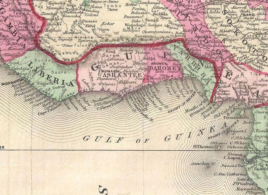
The Ashanti Empire took advantage of the trade opportunities and became wealthy. By the time the Europeans arrived, Ashanti trade relationships were well established and capable of supplying the colonial ships with slaves, ivory, and gold. The coastal area of Ghana was known as the Gold Coast during colonial times. Similarly, the country of Ivory Coast (Côte d’Ivoire) got its name from its participation in the elephant ivory trade.


The Ashanti were known for their involvement in the slave trade and today must live with that legacy.
This region of West Africa bordering the Atlantic was called the Slave Coast because of the high number of local people from this area who were sold into the European slave trade and shipped to the Americas. The once-powerful Kingdom of Dahomey, east of the Ashanti Empire, was heavily involved in the slave trade. Slave trading with Europeans brought them rifles and other firearms that were useful in conflicts with their regional adversaries. A major slave state along the Slave Coast, the kingdom attracted the spite of its neighbors as a pariah state for selling its war captives into transatlantic slavery rather than killing them, as was the custom in warfare. The Kingdom of Dahomey became the country of Benin after the colonial era.
The slave trade brought wealth to many of the slave-trading kingdoms on the African coast. The demand for slaves pushed many of the African kingdoms to expand their slave-trading activities, capturing more individuals whom they could sell to European slave traders. Millions of Africans were captured by other Africans only to be sold into slavery, placed on ships, and sent to slave owners in the Americas. The total number sold into the Atlantic slave trade will never be known, but estimates range somewhere between ten and twelve million.
Niger

The former French colony of Niger is landlocked, with the Sahara Desert making up its largest portion. Niger is a land of subsistence farmers, and most of the population lives in the southern regions.

The country is less than 20 percent urban. Other economic activities include uranium mining, which is the country’s main export. The world demand for uranium has not been strong in recent years.
Oil exploration has begun and international oil corporations have garnered contracts for drilling.
The Sahara Desert is moving southward, and the agrarian culture at the base of Niger’s society is often plagued by drought and famine. The Niger River flows through the southwestern region and provides fresh water, but the northern region is mainly the Sahara Desert, and large portions are covered with sand dunes.

he southern parts of Niger are naturally dominated savannas. The W National Park, situated in the bordering area to Burkina Faso and Benin, belongs to one of the most important areas for wildlife in Western Africa, which is called the WAP Complex. It has the most important population of the rare West African lion and one of the last populations of the Northwest African cheetah. Other wildlife includes elephants, buffaloes, roan antelopes, kob antelopes, and warthogs. Giraffes live further north in Niger.


The country has extreme demographics. Niger has the highest fertility rate (7.6) in the world, and half the population is under the age of fifteen, causing a population explosion that taxes the sparse natural resources and brings even more poverty to a country at the bottom end of the index of economic development. Infant mortality rates in Niger have been the highest in the world.
The mainly Sunni Muslim country has a rich cultural base but suffers from economic problems that appear to increase with the increase in population and desertification. Heavy national debt has hindered social services and has required a considerable amount of foreign aid from a number of sources. As a former colony, Niger, France has been a main contributor to providing economic aid along with the United Nations (UN).
The political conditions in Niger are typical of the region. For the first thirty years after independence from France, the country was ruled by a single political party and military rule. There have been several coups and various political leaders have been in power. A dispute remains with Libya over its northern border. Ethnic infighting with a minority Taureg group has emerged in recent years, bringing conflict and discord. The Taureg, found throughout northwest Africa in the interior Saharan region, have many ethnic clans and have been masters of camel caravans, often with a nomadic heritage. Their clothing is often made of cloth colored with an indigo dye that distinguishes them from other ethnic groups. The Taureg fought historic battles for an independent homeland against the French during the colonial era.
Mali
To the west of Niger is Mali, another landlocked Muslim country dominated by the Sahara Desert. Mali was home to various ancient empires. Wealth was historically gained from the mining of gold, salt, and copper. The Niger River flows through the entire southern region, providing a means of transportation and fishing as well as fresh water. The ancient city of Timbuktu, once a port on the Niger River, was a center of commerce and trade for the region and was used by the Taureg as early as the tenth century.
The Taureg are a people who have been called the “blue people” for the indigo dye colored clothes they traditionally wear and which stains their skin. They are a semi-nomadic Muslim people, believed to be descendants of the Berber natives of North Africa. In Tuareg society, women do not traditionally wear the veil, whereas men do.

Timbuktu has played an important role as an educational focal point for many of the peoples of the region. The University of Timbuktu is noted for its educational activities and comprises various colleges and madrasas (Islamic schools of learning). At one point in its history, it claimed to hold the largest collection of books in Africa. The capital city of Mali is not Timbuktu but Bamako, which is located in the southwest. Timbuktu remains a main tourist destination for the country and the region.
International Culture and the Power of the Soap Opera
Timbuktu (Tombouctou) is a key city for the country of Mali in the middle of the Sahel. The city has been stereotyped by people in Western culture as the farthest place from civilization on Earth. In reality, it is a thriving city that is well connected to the globalization activities of the rest of the planet. It was once one of the wealthiest cities in the world. Gold was plentiful, and the city was home to one of the largest universities in the ancient world. Today the city exhibits traits similar to North Africa but is in the African Transition Zone. Modern technology has found its way into the lives of the people of Timbuktu. International exchanges are providing interesting insights into the globalization process. Even in the rural areas, the people have found innovative ways to share in the international dynamics of global cultures.
Dr. Ibrahim N’diaye, originally from Mali and as of 2011 a history instructor at Morehead State University in Morehead, Kentucky, tells a story about his experience while visiting the rural Mali village of Koriyome as a member of the planning committee for the “Tombouctou 2000” millennium commemoration festival the Mali Ministry of Culture was sponsoring at the time. He noticed that in the evening at a certain time, the people of the village started up gas-powered electric generators and then gathered around television sets connected to a satellite feed throughout the village. The evening feature was a Brazilian soap opera called Mari Mar. It was broadcast in Portuguese, a language no one spoke in the village. The seminomadic villagers were totally immersed in the soap opera and had even altered the names of the key characters to match local names. For example, they referred to the main character Mari Mar as “Mariyama” (which is the same as Mari/Mary); Mari Mar’s husband, Sergio, as “Saajo”; the cruel stepmother Angelika as “Jelika”; and so on. Everyone in the village seemed to understand the plot and reveled in the drama of the characters and their exploits. The production became a centripetal force that brought the villagers together in a way that would not have been expected by anyone in Brazil or the United States. Who would have believed that soap operas would have become a method of diffusing global culture to the planet? This story also indicates that human nature is similar in societies throughout the world.
Senegal and the Gambia

The country of Senegal on the Atlantic coast totally surrounds the independent country of the Gambia. Senegal was a French colony, while the Gambia was a British colony. The Gambia is an enclave of Senegal and extends on both sides of the Gambia River for about 186 miles. It is the smallest country on the mainland of Africa and is about the size of the US state of Connecticut.

The two countries of Senegal and the Gambia were united into the confederation of Senegambia from 1982 to 1989 when it was dissolved. They have kept separate political identities ever since.
The capital of Senegal, Dakar, is located on the Cap Vert Peninsula, which is most extreme western extension of the African continent. Dakar was a main colonial port for French West Africa during colonial times.

The French influence remains: the common currency in what were former French colonies is the West African CFA franc (Central African franc), which has a fixed rate in relation to the euro.
Nigeria

Africa’s most populous country is Nigeria. The exact population has been difficult to determine, but 2020 estimates report the population to be over 205 million. This is a country of more than 250 different ethnic groups with twice that many separate languages or dialects. English is the official language, along with Hausa, Yoruba, and Igbo (Ibo), all of which are spoken by ten million people or more.


The distribution of the major ethnic groups is illustrated by the different regions of the country. Hausa groups are found mainly in the northern region, Kanuri groups in the northeast, Yoruba in the southwest, and Igbo (Ibo) in the southeast.

Ethnic division has also caused serious confrontations and violence. In 1967, a separatist movement in the eastern Igbo region created the independent nation of Biafra. This sparked an all-out civil war that lasted more than two years and resulted in more than a million deaths. Political divisions did not end even after the two sides reconciled and the country was united under the same government in 1970. Political instability in Nigeria has resulted in an almost endless number of military coups and government leaders being removed from office.
Religious issues add to the political instability. The north is mainly Muslim, as it is located in the African Transition Zone. The south is mainly Christian. A large percentage of the population follows animist religions with many different traditional beliefs. Clashes have erupted in the streets that pit Muslims and Christians against each other. Several northern provinces have pushed to have the Sharia criminal code made into the area’s civil law. There are regions where it is not uncommon for people to have a mix Christian and animist beliefs.
Nigerian cuisine consists of dishes or food items from the hundreds of ethnic groups that comprise Nigeria. Like other West African cuisines, it uses spices and herbs with palm or groundnut oil to create deeply flavored sauces and soups. Nigerian feasts are colorful and lavish, while aromatic market and roadside snacks cooked on barbecues or fried in oil are in abundance.


Family size has been large in Nigeria, which has caused an exploding population. Statistically, Nigeria has more people of African heritage than any other country in the world. The population density is equivalent to having half the population of the United States pushed into an area the size of Texas and Oklahoma.

She had her first baby at the age of 15 and delivered safely in a health clinic with the care of a trained professional. She now tells other girls about her experience and encourages them to go to local clinics for routine check ups and delivery. She also gives them advice about how to space children using family planning.
Most of the population makes their living on subsistence agriculture, but millions are employed in the growing urban service sector. Nigeria’s main economic engine is the oil industry, which accounts for up to 80 percent of government revenues and is the number one export product. Nigeria is a member of the Organization of Petroleum Exporting Countries (OPEC) and is one of the world’s top ten oil-exporting countries.
The lucrative oil business has attracted many seeking to share in the profits. The government’s distribution of oil revenues has brought about even more infighting, corruption, and mismanagement within the political leadership. Rebels and militant groups along the Niger Delta, where most of the oil activity is located, have attacked the oil industry’s infrastructure and taken workers hostage. They want a larger share of the revenues to remain in Nigeria and to go to their people rather than the government or CEOs of international corporations.
Warning: There is some strong language in the following video (as well as an incidence of taking God’s name in vain).
Poverty, a low standard of living, the lack of opportunities and advantages, a poor educational system, or the lack of social services does not diminish the human spirit. Confronting all these issues and more, the people of West Africa and Nigeria are vibrant, energetic, and hard-working and value the institutions of family and religion. Just because they have not transitioned to a consumer society does not mean they cannot find fulfillment and happiness in their lives. A survey conducted by social scientists in 2001 and reported by BBC News in 2003, indicated that Nigeria had the highest percentage of happy people of any country in the world at that time. The status of each country may change from year to year, but the interesting part is that the survey confirmed that money or income level does not always equate to happiness. Countries such as Nigeria, with a low level of per-capita income, can still highly value their heritage and the traditions that revolve around their family and community and transcend the global push for economic gain and the possession of consumer items. Much can be said for the vibrant cultural attributes of the people of West Africa and its developing countries.
We want to know what you thought of what you just read and watched! Leave us a comment! Please also let us know if a link or video isn’t working.
Next: Central African Republics
Additional information and image credits:
Timbuktu Updated from map courtesy of Andreas 06, https://open.lib.umn.edu/worldgeography/chapter/7-1-introducing-the-realm/
West Africa map Updated from map courtesy of University of Texas Libraries., https://open.lib.umn.edu/worldgeography/chapter/7-3-west-africa/
Niger map By OCHA, CC BY 3.0, https://commons.wikimedia.org/w/index.php?curid=32649461
Woman in Niger By Photo: ILRI/Stevie Mann – Woman carrying traditional water pots for sale in Niger, CC BY 2.0, https://commons.wikimedia.org/w/index.php?curid=12194759
https://en.wikipedia.org/wiki/Niger
Niger boys and street By NigerTZai – Own work, CC BY-SA 4.0, https://commons.wikimedia.org/w/index.php?curid=77363791
Cheetah By Steve Wilson – over 6 million views Thanks !! from Chester, UK – NorthWest African Cheetah, CC BY 2.0, https://commons.wikimedia.org/w/index.php?curid=40569414
Roan antelope By Charles J Sharp – Own work, from Sharp Photography, sharpphotography, CC BY-SA 4.0, https://commons.wikimedia.org/w/index.php?curid=37058729
Ghana Empire map By Luxo – Image:BlankMap-World gray.svg, CC BY-SA 3.0, https://commons.wikimedia.org/w/index.php?curid=1097270
Mali Empire CC BY-SA 3.0, https://commons.wikimedia.org/w/index.php?curid=552646
Songhai Empire By No machine-readable author provided. Roke~commonswiki assumed (based on copyright claims). – No machine-readable source provided. Own work assumed (based on copyright claims)., CC BY-SA 3.0, https://commons.wikimedia.org/w/index.php?curid=552651
Ashante map By Nerika – Own work, Public Domain, https://commons.wikimedia.org/w/index.php?curid=27556983
Ghana By OCHA, CC BY 3.0, https://commons.wikimedia.org/w/index.php?curid=34826113
Ivory Coast map By OCHA, CC BY 3.0, https://commons.wikimedia.org/w/index.php?curid=31591811
Taureg men By Alfred Weidinger from Vienna, Austria – Touaregs at the Festival au Desert near Timbuktu, Mali 2012Uploaded by Tomer T, CC BY 2.0, https://commons.wikimedia.org/w/index.php?curid=18703528
Senegal map By OCHA, CC BY 3.0, https://commons.wikimedia.org/w/index.php?curid=34011368
Gambia map By OCHA, CC BY 3.0, https://commons.wikimedia.org/w/index.php?curid=34854996
Dakar By Jeff Attaway from Abuja, Nigeria – Beach @ Ngor, CC BY 2.0, https://commons.wikimedia.org/w/index.php?curid=18241990
Nigeria By OCHA, CC BY 3.0, https://commons.wikimedia.org/w/index.php?curid=32649777
Nigeria linguistical map By Hel-hama – Own work, CC BY-SA 3.0, https://commons.wikimedia.org/w/index.php?curid=25241065
Hausa By Melvin Baker – www.flickr.com, CC BY 2.0, https://commons.wikimedia.org/w/index.php?curid=1053732
Igbo By infomatique – https://www.flickr.com/photos/infomatique/2812478793/, CC BY-SA 2.0, https://commons.wikimedia.org/w/index.php?curid=4688408
Nigeria https://en.wikipedia.org/wiki/Nigeria
Nigerian food https://en.wikipedia.org/wiki/Nigerian_cuisine
Suya By WhisperToMe – Own work, CC0, https://commons.wikimedia.org/w/index.php?curid=28189563
Ponmo By Raji Rasheed Seyi – Own work, CC BY-SA 4.0, https://commons.wikimedia.org/w/index.php?curid=64301620
Kulikuli By Kwameghana – Own work, CC BY-SA 4.0, https://commons.wikimedia.org/w/index.php?curid=37063647
Nigerian woman and baby By Susan Elden/DFID, CC BY-SA 2.0, https://commons.wikimedia.org/w/index.php?curid=26240089
Hi! Just letting you know in case you want to leave a note, the second to last video about oil in Nigeria uses strong language several times.
Thank you!!! I’ll put a warning! <3